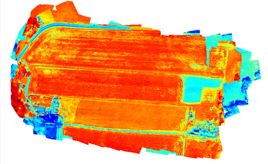
RSI’s Epoch 2EQ project uses UAV-based sensors and image-processing technology to generate scientific quality data products that can inform farmers of crop health. We have performed successful field tests of a local farm using a two-band spectral imager. The spectral filters are attached to a single camera sensor; the split-wavelength images are then divided in post-processing to later be merged in the final orthomosaic. This process produces LandSat- quality NDVI (Normalized Difference Vegetation Index) data with greater resolution, repeatability, and flexibility than achievable with LandSat data. The process has the following steps:
1. Images are captured in two wave bands (typically 655nm and 865nm wavelengths) as the drone carries the camera over the target field.
2. The images are processed and radiometrically calibrated.
3. Anorthomosaic is created from each waveband.
4. The NDVI is created from the orthomosaics.
More detailed images allow for higher precision in yield estimates as more light data allows for accurate NDVI images. Precise yield estimates and crop health approximations will allow farmers to make more informed decisions on how to better nurture their crop. RSI has developed a single processing pipeline that adheres closely to Landsat standards for radiometric calibration and image correction including;
- Removal of blurry images
- Flat field correction
- Vignetting correction
- Variable light correction
- Correction for BRDF that varies with view angle and diffuse light
- Conversion to radiances
This system can be easily modified for various platforms and to measure other useful indices such as NG, NNIR, Red Edge and MSAVI.
Refer questions about our imaging or processing capabilities to Tai Ragan.